Yesterday, 82.9% of the Midwest Region was snow covered. Today, that has now dropped down to 73.5%. Typically, we don't start this snowy this early. Yesterday, 67% of the nation was covered in snow, highest for December 9th since data collection started. Today, that has now dropped down to 63.3%. Here in Indianapolis, we have now seen 5.1" of snow since December 1st. This is 3.6" ahead of pace. The average snowfall amount for December 1-10 is 1.5". As a month, the average snowfall amount is 6.9". We only have 1.8" of snow to go and at this distance it looks like we'll pass the normal amount.
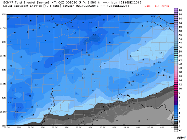
The Weather finally goes quiet for a few days. Lots of sunshine is store for the next few days. Clouds will increase on Friday and snow looks to creep back in Friday Night into Saturday. This seems to be a complex system. Will need to watch the temperatures. It looks like midday Saturday this could change over to a a brief period of a wintry mix of rain, freezing rain, sleet, and snow especially for areas along and south of I-70 but after the sun sets we look to change back to all snow. This looks to continue into Sunday. The heaviest areas will set up likely along and North of I-70 which could include Indianapolis but Northern Indiana will get mostly all snow and because so, they'll see the most snow which could exceed 5". In Central Indiana, where are likely to see more than 2" but less than 6" of snow. Those south of I-70 are likely to see less than 4" or even 3" of snow. Below are images from the GFS and European Model on the weekend winter storm. You can see the model average in the last image. One model brings in 5.5" to Indianapolis.


.png)
.png)
I'm watching for more smaller snow chances. The next overnight Monday ending before sunrise Tuesday morning. This may lay down an 1" or less (similar to last night). Also another chance Tuesday Night into Wednesday. This system may come in just a tad higher with totals possibly between 1"-2". Then again, we'll need to watch the December 20th-23rd time frame for another storm system which could fall as rain or snow or both. The current weather pattern is refrigerating temps and the snowpack is only helping to preserve the chill. Its safe to say the month will finish with above normal snowfall and below normal temperatures.


No comments:
Post a Comment