In the chart below, I've outline records set this year in Indianapolis for the period of January 1st-June 30th. These are for new record high temperatures set, and for records for warmest overnight low temperatures as well. So far 10 record highs have been broken, 1 high tied on June 30th. There were 5 Warmest Lows Temps broken with 1 tied on March 18th.
| Date of New Record 2012 |
Record High Temperature |
Previous Record High Temperature |
Record Highest Minimum Temp. |
Previous Record Highest Minimum Temp. |
| JAN. 31st | N/A | N/A | 50° | 48° (1988) |
| FEB. 29th | N/A | N/A | 45° | 44° (1976) |
| MAR 14th | 81° | 79° (1990) |
N/A | N/A |
| MAR 15th | 80° | 77° (1977) |
N/A | N/A |
| MAR 17th | 77° | 76° (1894) |
N/A | N/A |
| MAR. 18th | 80° | 76° (1903) |
60° TIED |
60° (1874) |
| MAR. 19th | 82° | 78° (1921) |
64° | 60° (1903) |
| MAR. 20th | 83° | 80° (1894) |
63° | 62° (1921) |
| MAR. 21st | 84° | 82° (2007) |
62° | 58° (2011) |
| APR. 3rd | 84° | 83° (1946) |
N/A | N/A |
| JUN 28th | 104° | 101° (1934) |
N/A | N/A |
| JUN 29th | 103° | 100° (1934) |
N/A | N/A |
| JUN 30th | 97° TIED |
97° (1933) |
N/A | N/A |
Here's the Monthly Observations for January 2012-June 2012:
| Month of Year |
AVG. High Temp. |
AVG. Low Temp. |
AVG. Monthly Temp. |
Precip | Snowfall |
| JANUARY | 41.9° | 29.5° | 33.7° | 3.48" | 4.40" |
| FEBRUARY | 45.5° | 29.1° | 37.3° | 1.38" | 2.20" |
| MARCH | 67.1° | 46.1° | 56.6° | 4.14" | 0.70" |
| APRIL | 65.2° | 43.8° | 54.5° | 3.36" | NONE |
| MAY | 79.6" | 58.0° | 68.8° | 2.70" | NONE |
| JUNE | 86.4° | 62.7° | 74.5° | 0.09" | NONE | JAN-JUNE | 64.2° | 44.8° | 54.2° | 15.50" | 7.30" |
June 2012
Temperatures once again are finishing above normal for the 17th out of the past 19 months (December 2010-June 2012). This, even after the month starting 12° below normal the first day & -5° from normal for the first 7 days. But a stretch of hot days in the middle of the month began to iron the temperatures out. This warm weather lingered to end of the month climbing to the hottest temperatures this year causing numerous record highs temperatures to fall that dates back to the dust bowl years of the 1930s. As of yesterday, we've recorded 24 consecutive days with temps 80° and above. In the middle of that, we recorded 4 consecutive days with temps 90° and above..twice. June finishes with one day with a high temp in the 60s (June 1st), 4 in the 70s, 13 in 80s, 10 in 90s, and 2 days with high temps in the triple digits. This puts the average high for June at 86°. For low temps, we've recorded one morning in the 40s (June 2nd), 11 days in the 50s, 10 in the 60s, and 8 days with low temperatures in the 70s. This puts the average low for June at 63°, averages combined, the monthly temp for June 2012 finishes at 75°.
As for precipitation, we finish well below normal. Only scooping up a whooping 0.09" this is good for the driest June on Record. This bumps 0.36" set in 1988 to position #2. There were 24 consecutive days without measurable precipitation at Indianapolis International Airport beginning June 5th and ending June 28th. This is a record for June and its the longest period without measurable precipitation since 1983.
Here's a Radar look at what was classified as "Derecho"
 A derecho (pronounced similar to “deh-REY-cho” in English) is a widespread, long-lived wind storm that is associated with a band of rapidly moving showers or thunderstorms. Central Indiana was under the outflow boundary of this system and Indianapolis recorded 0.04" of precipitation and a peak wind gust of 56 MPH. This ended the streak of dry days in the city.
We finished the month over 4" below normal and now approaching 7" below normal for the year. Here's the updated chart for the rainfall deficit around the state.
Rainfall Deficit Around the State
| Location | Year to Date Precipitation (through June 30) | Departure from Average | June Precip | Departure from Average |
| Indianapolis | 15.15 | - 6.50 | 0.09 | -4.16 |
| Lafayette | 11.56** | - 6.56 | 0.81 | -3.29 |
| Muncie | 13.88 | - 6.35 | 1.64 | -3.02 |
| Terre Haute | 12.53 | -10.35 | 0.23 | -4.21 |
| Bloomington | 11.95 | -12.83 | 0.20 | -4.69 |
| Shelbyville | 13.10 | - 9.08 | 0.05 | -4.35 |
| Indy - Eagle Creek | 13.35 | - 7.85 | 0.21 | -4.18 |
| SUN | MON | TUES | WED | THURS | FRI | SAT | |
|---|---|---|---|---|---|---|---|
| High Temp | 92 | 86 | 83 | 91 | 104 | 103 | 97 |
| Low Temp | 72 | 69 | 59 | 59 | 70 | 73 | 70 |
| Precip | NONE | NONE | NONE | NONE | NONE | 0.04" | TRACE | Peak Wind Gust (MPH) | 17 | 29 | 23 | 21 | 28 | 56 | 45 |
July 2012
Average High: 85°||Average Low: 66°||Average July Temp: 75°||Average Precip: 4.55"
July 1st- Sunrise: 06:21AM Sunset: 09:17PM <------Length of Day: 14 Hrs 56 Mins 01 Secs
July 31st-Sunrise: 06:43AM Sunset: 08:58PM <------Length of Day: 14 Hrs 15 Mins 09 Secs
During the Month of July, Indianapolis loses a total of 40 Mins 52 Secs of Daylight.
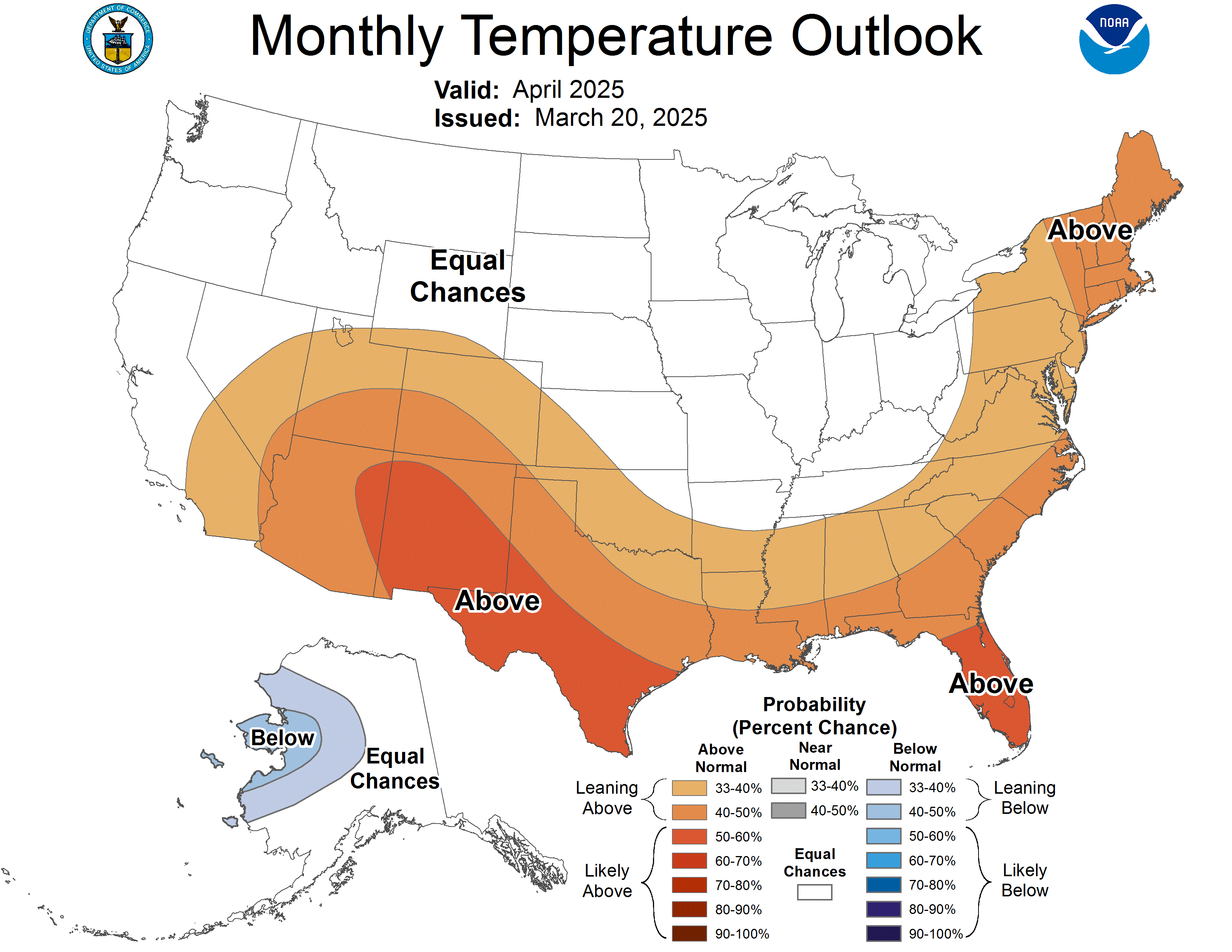
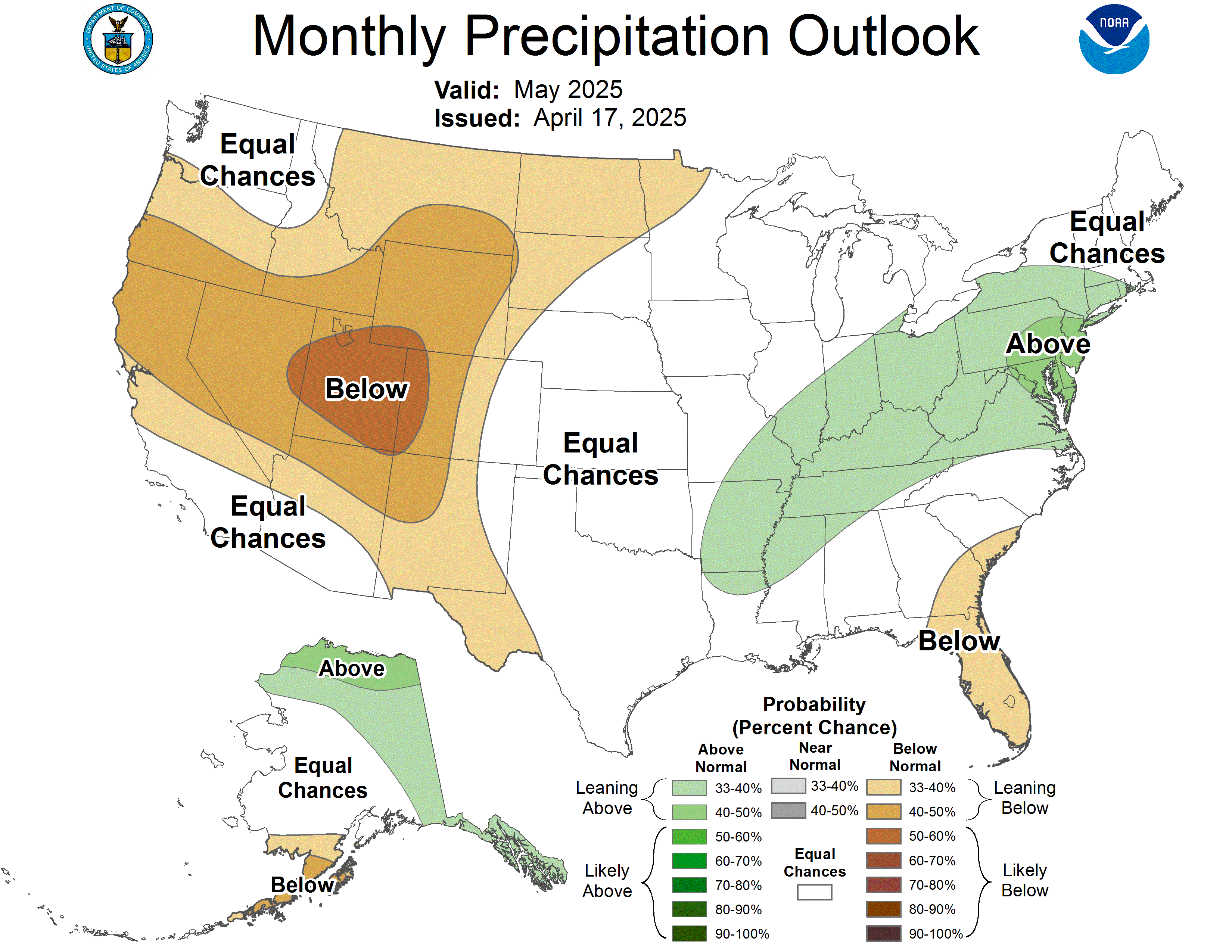
6-10, 8-14, & 30 Day Temperature and Precipitation Outlooks
Over the next 6-10 Days the temperatures are expected to remain above normal. The average high for the first week of July is 85°. High Temperatures are forecasted to remain above the 90° mark for the first week of July and above 85° for the next 6-10 Days. Precipitation is forecasted to remain well below normal for the first half of July.
 |
 |
Over the next 8-14 Days,second week of July, temperatures are forecasted to cool off to possibly below average temperatures. The Normal High for the second week of July is again 85°. Better chances for Precipitation is likely to occur with the cooler temperatures, however, precipitation is still forecasted to be below normal.
 |
 |
During the month of July, temperatures are expected to finish above normal with below normal precipitation.
 |
 |
During the month of July, comes Independence Day. This days has been set aside to light off firework making for a beautiful display in the night time sky. With current abnormally dry conditions many are banned from lighting fireworks on this special holiday. However, professional diplays licensed by the state will be allowed to fire off. This week your holiday forecast looks to be dry and hot with temperatures in the 90s. Similiar to the last two days of June, there will be the possibility for some brief thunderstorm activity but during the summer months, its sometimes hard to forecast severe weather until the day of. Stay Tuned.
Here's a look at a few extreme weather recorded in the Holiday's History:
Hottest Holiday: July 4th, 1911--103°
Coolest Holiday: July 4th, 1948--48°
Wettest Holiday: July 4th, 1957--2.4" fell
Last year, Central Indiana had what's called a Heat Burst on July 3th which was like a "pre-fireworks" lightning show. The temperatures spiked from 72° at 1AM to 86° at 2AM (Eagle Creek Airpark Observations). The dewpoint dropped from 63° to 50° and the relative humidity plummeted from nearly 70% to slightly below 30%. Winds gusted to 48 MPH at Indianapolis International Aiport. For more details on this rare occurence the NWS Indianpolis, IN has a write up on it. Click HERE for more details. A heat burst are typically associated with decaying thunderstorms and occur during the nighttime hours. Nearly 20 of this rare phenomenons have been documented over the past 16 years.
Here's our Observations over the Past 5 Yrs.
2011-High: 85 Low: 67 Precip: 0.01
2010-High: 91 Low: 69 Precip: NONE
2009-High: 70 Low: 63 Precip: 1.03"
2008-High: 71 Low: 61 Precip: 0.69"
2007-High: 84 Low: 65 Precip: 0.03"
Here's my Hourly Breakdown (3 HR Increments) for the Holiday.
12AM-83° Partly Cloudy || 3AM-81° Partly Cloudy || 6AM-78° Partly Cloudy
9AM-82° Partly Sunny || 12PM-90° Partly Sunny || 3PM-95° Partly Sunny
6PM-93° Partly Sunny || 9PM-88° Partly Cloudy || 12AM-84°
There is a 20% Chance of Thunderstorms During the Hours of 3-9PM.
Dought Analysis & Burn Ban
Dry Conditions continue to persist across the State of Indiana. Thursday, CPC issued its weekly drought analysis. 99% of the State is Abnormally Dry. 87% of the State is under atleast a Moderate Drought. 68% of the State is under a Severe Drought. 23% of the state is under an extreme drought.

The lack of rain over the past 2 months especially June, has been quite a concern. There are 92 Counties in Indiana and 85 Counties have issued a burn ban. This means any type of burning is prohibited. For most, this also means fireworks. Indiana Code 22-11-14-10.5 on fireworks is supposed to prevent government and firefighter officials from banning fireworks during the holiday from June 29th-July 9th during certain times of the day. However, officials are working around the law. Indianapolis Mayor Greg Ballard has issued a local disaster emergency declaration for Marion County, Indianapolis and signed an Executive Order banning personal firework displays. This means YOU CANNOT light fireworks. Failure to comply could result in a hefty fines up to $2,500. This order, however, excludes professional firework displays sanctioned by the state. This means fireworks will still be displayed at the Indianapolis Indians vs Louisville Bats ballgame at dusk and the Regions Bank Freedom Blast. The freedom blast is Indiana's Largest Fireworks Display and will kick off at approxiametely 9:45PM shot from the top of the Regions Bank Tower downtown.

With the persistence of dry soils and hotter temperatures. Red Flag Warnings continue to remain in effect for some parts of the state.
Also in effect is Excessive Heat Warnings as temperatures continue to remain above 90. Drink Plenty of Water, Wear Loose Clothing, Limit outdoor time and activities, and check on Elderly & Pets. These are a few helpful tips to Beat the Heat.
This Week
After an astonishing run at 100s last week, we'll try again this week. If I haven't already done so, let me formerly introduce the season, welcome to Summer guys! Over the next few days we'll keep the chance for some isolated thunderstorms. Similiar to the past few days, its hard to determine where severe weather will particularly strike especially during these summer months. For Today, SPC has issued a Slight Risk for Severe Storms for much of Iowa, Illinois and Indiana, extending into the Ohio Valley, parts of the mid Atlantic, and down in the Southeast Region of the nation. Large Hail, Damaging Winds, and Plenty of Lightning. are the greatest risks.

The heat and humidity will continue to be there. Added moisture in the atmosphere keeps the threat for thunderstorms in my forecast for Monday, Tuesday, and Wednesday as well, some of which could be severe. Keep in mind, some areas of the state could very well stay dry. These are hit and miss chances. In between, there will be plenty of sunshine and dry hours.
This Week in Indiana History
July 1, 1987-Two people are killed by flash flooding.
July 4, 1911-Indianapolis records warmest Independence Day at 103°.
July 7, 1915-Terre Haute receives 1.30" of rain in only 10 minutes.
10 Day Detailed Outlook
Today-Mixed Sun & Clouds. Chance of T'Storms. High 96.
Tonight-Mostly Cloudy. Chance of T'Storms. Low 75.
Monday-Partly Sunny. Hot. Chance of T'Storms. High 97.
Monday PM-Partly Cloudy. Chance of T'Storms. Low 76.
Tuesday-Partly Sunny. Hot. Chance of T'Storms. High 98.
Tuesday PM-Partly Cloudy. Chance of T'Storms. Low 75.
Wednesday-Partly Sunny. Hot. Chance of T'Storms. High 98.
Wednesday PM-Partly Cloudy. Chance of T'Storms. Low 77.
Thursday-Mostly Sunny & Hot. High 99.
Thursday PM-Partly to Mostly Clear Skies. Mild. Low 78.
Friday-Mostly Sunny & Hot. High 100.
Friday PM-Clear Skies. Low 80.
Saturday-Mostly Sunny & Hot. High 102.
Saturday PM-Partly Cloudy. Low 80.
Sunday-Mixed Sun & Clouds. Chance of T'Storms. High 96.
Sunday PM-Partly Cloudy. Chance of T'Storms. Low 74.
Monday-Mixed Sun & Clouds. High 91.
Monday-Partly Cloudy. Cooler. Low 70.
Tuesday-Mostly Sunny. Seasonal. High 86.
Tuesday PM-Partly Cloudy. Low 69.
No comments:
Post a Comment