Good Morning! A low pressure system is bringing us some showers today. Less than quarter of inch total expected. There is a chance for severe weather for southern portions of Indiana. Hail and maybe some damaging winds biggest threat. Also, along IN/KY Border theres that possbility of Tornadoes but looks slim since its too early to tell. A cold front looks to sweep pass the state overnight tonight this could give us steady to falling temps for Friday.
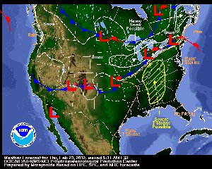
If you look at my illustration below, there is snow falling up in the Dakotas. All kinds of Winter Warnings and Advisories in place. This moving East which will impact Chicago, Detriot, and Cleveland late tonight, tomorrow morning, into tomorrow evening. There are expecting 4-8" of snowfall along this track. Some could effect Central Indiana tomorrow. We could get less than a quarter of an inch accum by Sat AM. This could mix in with some drizzle, maybe sleet. Since we might be dealing with some falling temps going below freezing, this could create some Black Ice for Saturday morning so be careful if your traveling on the roads but this powerful but non-significant system (in Central Indy) is not expected to be a mess. Just follow safe driving practices you'll be fine.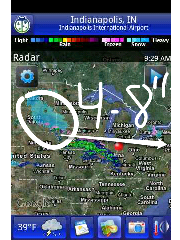
The balance of the weekend looks dry. In fact, Sunday looks great with abundant sunshine in temps in mid to upper 40s. Another system moves in overnight on Sunday into Monday. This brings our next rain chance and the possibility of some Morning or Early Afternoon Thunderstorms with temps around the 50° mark. Once again, another cold front will pass dropping our temps for Tuesday and Wednesday next week. Looking at another storm system that could help produce some snowflakes mid week. More Details on this to come in the upcoming days.
Here's my forecast for Today & 7 Day Outlook:
Today-Scattered Showers. Breezy. Mild. High 53°
Tonight-Rain. Windy. Low 42°
Tomorrow-Rain changing to Snow (after 7am), Wintry Mix. Windy. Near Steady Temps around 40° at midnight then falling.
Saturday-AM (Chance of) Flurries & Frigit Start. Morning Low Temps in Upper Teens, Low 20s. Intervals of Clouds & Sun for day. High 33°
Sunday-Bright Sunny Skies. Warmer. Light Breeze. High 46°
Monday-Cloudy with Rain. Chance of T'Storm. Windy. High 50°
Tuesday-Partly Cloudy. Chance of Flurries. Cooler. High 38°
Wednesday-Chance of Snow Showers. Cool. Breezy. High 35°
Thursday-Chance of Morning Flurries, otherwise Partly Sunny, some Clouds. High 40°
No comments:
Post a Comment