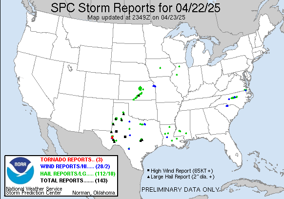
Good Afternoon! Well the storms have passed through Indiana and pushing off to the East Coast. Since there wasn't much instability here it was not intense in Indianapolis. However, one tornado touchdown to the extreme Southeastern part of the state was reported in Switzerland, IN. This touchdown was very brief in an open field North of Center Square doing little to no damage. Hail seemed to have been our biggest threat here all around the state. Twenty hail reports were logged last night. Shelbyville got a good accumulation of hail (4"), the stuff came down for 15 mins non-stop. They had to remove it with a snow plow truck, residents say it looked like a blizzard. (See Photo 2 Below).
SPC Storm Report Map for Yesterday
Shelbyville Hail (Courtesy of WTHR-13 Indianapolis, IN)
Yesterday
We picked up 0.11 & 1.34" of rainfall for Thursday and Friday, respectively, totaling 1.34". Friday was the most rainfall in one day we've seen since October 19th, 5 months ago, when we recorded 1.33".
Well yesterday cut our 11 Day streak of Temps above 70°. This is a record event and can officially go into the books. We missed it by 1°, recording 69°. Areas away from the NWS Indianapolis Airport went over the 70° mark though by a few degrees. So far this month we've had 1 day with highs in 30s, 3 in 40s, 2 in 50s, 6 in 60s, 4 in 70s, and 7 days this month have been in 80s. Five occuring consecutively. We have set nearly 20 record events this month of March. Just historic. We may never get to see this weather again in March. These temps observed are more typical for Tampa, Florida this March. To date in Tampa all but 2 days have been in the 80s this month. They recorded 70s back to back on the 4th & 5th. To have warmth spread far North up here not too far from Great Lakes its simply remarkeable and perhaps once in a lifetime. We broke century old records. It could be another 100 yrs when our great or great great grandkids are recording new records, either way, we personally may not exprience them in our lifetime again. I have compiled my own list of records this yr. Click here to see them.
This weekend
Well today the upper level low that brung these showers and storms for much of the Central U.S. will be sitting on top of us here in Indiana. This will keep us cool preventing us to go above the mid 60s, and also keep a small chance of a spotty shower or t'storm here for the state. Nothing severe. As the upper low pushes out the state by tomorrow, this will warm our temps up in the 70s and also give us mostly sunny skies. Nicest day of the weekend. Our rain chances will diminish tomorrow as well.
Upcoming Work Week
Week shouldn't be all that bad with plenty of sunshine and minimal chances of rain. Looks like Tuesday Evening into Wednesday Morning would be our best shot though at some wet precipitation. High Temps will be the 60s and 70s, Low Temp mostly in 40s and 50s.
Whats Ahead
There continues to be a shot of a even chillier cool down for the first half of April, as mentioned for several weeks now. Highs could dip in 50s, maybe even a 40° day. Lows could fall back in 30s, maybe even a morning back into 20s. Folks the average last freeze is April 22nd. So far, our last freeze date was March 10th.
I expect the month of April to go from above average to below average temps in the first half of month. However, the month will probably finsh will a avg temp that is normal for the month. I think the second half of the month we'll have normal April Temps with highs in the mid to upper 60s, and lows in the upper 40s to low 50s. For now, I'm putting a chance of a hard freeze between the 8th-12th day of April. Have to wait, to see how this plays out.
10 Day Detailed Outlook & Updated Precip/Snowfall Data:
Today:
Mixed Sun & Clouds. Chance of Spotty Showers. Cooler. High 63.
Saturday Night:
Partly Cloudy. Chance of Spotty Showers. Cooler. Low 50.
Sunday:
Clearing Clouds give way to Plentiful Sunshine. Warmer. High 72.
Sunday Night:
Partly Cloudy. Cool. Low 46.
Monday:
Abundant Sunshine. Cooler. High 62.
Monday Night:
Partly Cloudy. Cooler. Low 40.
Tuesday:
Partly Cloudy. Some Sunshine. Mild. Warmer. High 71.
Tuesday Night:
Partly Cloudy. Chance of Rain. Low 57.
Wednesday:
Mixed Sun & Clouds. Chance of Rain. Warmer. High 77.
Wednesday Night:
Partly Cloudy. Cooler. Low 49.
Thursday:
Partly Sunny. Mild. High 66.
Thursday Night:
Partly Cloudy. Cool. Low 45.
Friday:
Partly Sunny. Mild. High 68.
Friday Night
Partly Cloudy and Cool. Low 49.
Saturday
Mostly Cloudy. Chance of Rain. High 65.
Saturday Night
Mostly Cloudy. Chance of Rain. Low 52.
April Fools Day
Mixed Sun & Clouds. Chance of Rain. High 70
Sunday Night
Partly Cloudy. Low 53.
Monday
Partly Sunny. Mild. High 70.
Monday Night
Partly Cloudy. Becoming Cooler. Low 47.
Tuesday
Partly Clouy. Chance of Rain. High 60.
Tuesday Night
Mostly Cloudy. Increasing Chance of Rain. Cooler. Low 42.
Wednesday
Cloudy. Scattered Showers. Not as Warm. High 52.
Wednesday Night
Cloudy. Periods of Heavy Rain. Cool. Low 38.
Precip
Yesterday----------1.54"
Since March 1st----3.54"
Since January 1st---8.40"
Avg March Precip---3.56"
**24 HR Precipitation Map from Intellicast.com
Snowfall
Since March 1st----0.7"
Since Jan 1st---- 7.5"
Since Nov. 1st-- 9.8"
**Currently 8.6% of the Nations Ground is covered in Snow. NOAA Snow Depth Map below


No comments:
Post a Comment