Happy Meteorological Spring! After looking forward the next 2 weeks no snow systems in sight that will affect Indianapolis. A few flurries for Sunday & Monday but I am 95% sure that we may very well finish in the top 10 least snowiest winters with 9.1". We'll still will have opportunities for frost though. Last year, we had a week stretch of 70s then at the end of the month picked up 1.5" of snow. Thats where my other 5% confidentiality level goes. I cannot stand 100% sure we will not see anymore measureable snow.I got a look back at the numbers for February and the avg numbers for March. Also my updated 7 day. Just minor changes, pretty much the same as yesterday. And also I tell you why an NOAA Radio may come in handy tomorrow. Its all here below in my blog.
February 2012 Temps
Avg High Temp 46°
Avg Low Temp 29°
Avg February Temp 37°, we depart +5° Above Normal.
Highest Temp 69° (Feb. 29th)
Lowest Temp 14° (Feb. 11th)
We finish the month with 1 20° day, 9 30° Days, 9 40° Days, 8 50° Days, and 2 60° Days.
Nearly 66% of the days were spent above normal. (19 out of 29).
Rain
Total Precip for Month---1.38", finished 1.03" below normal.
Precip since Jan. 1st---4.86", so far 0.21" below normal for year.
Precip since Dec 1st---9.96", we are 1.81" above normal for season.
Snow
Total for Month---2.2", we finished 4.3" below normal.
Total since Jan 1st---6.8", currently 8.3" below for yr.
Total since Nov 1st---9.1", currently 12.9" below normal for season.
March Average
Avg High March 1st is 45°. Avg Low March 1st is 28°.
Avg High March 31st is 58°. Avg Low March 31st is 38°.
Record High is 83° (3/31/1981) Record Low is -7° (3/2/1980)
Avg Monthly Rain/Precip: 3.56"
Avg Monthly Snow: 2.6"
Set Clock forward an hr on March 11th from 2AM (or 0200) to 3AM (or 0300).
Daylight Hrs Continue to Increase by 1 hr 18 mins.
NAM Model Guidance for Fridays Storm System

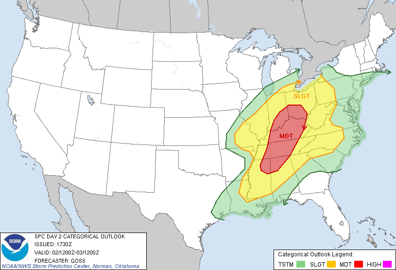
A low pressure system moving from West to East will pass through Indianapolis Friday Afternoon. SPC has placed Indiana under a moderate risk for severe storms. This storm system has the potential to bring strong gusty winds, hail, tornado threat, a very little flooding. Estimated Rainfall Totals less than 1". High temps in the mid 60s. Best timeframe for this severe weather is beetween 2pm & 10pm.
A Watch is an area that has the potential to either spawn a tornado or severe storm. This means you need to get with all your members of the household and develop a game plan to keep everyone in your family safe. This could also mean evacuation. This is Standby mode if you want to call it that.
When a Warning is issued, you need to take shelter immediately and implement the plan that your household has created to ensure everyones safety during this significant storm event. Failure to do so could result in deadly consequences. This is the importance of having a NOAA Radio so you can take heed to the watches and warnings advised. This system could weaken tomorrow but also it could strengthen. Regardless, this information has to be put out so you can be prepared for the worse, if it comes.
A dip in the jet stream will cause cooler air from the North to be pulled far enogh South to cool us off for the weekend. Looking at low 40s, perhaps upper 30s this weekend.

My 7 Day worded forecast:
Tonight
Mostly Clear. Low 43°.
Friday
Showers and thunderstorms likely, mainly after 1pm. Mostly cloudy, with a high near 65°. Rainfall Totals up to half inch possible (at this point)
Friday Night
Rain and Thunderstorms ending. Breezy. Additional quarter of an inch precipitation possible (at this point). Low 33°
Saturday
Mostly Coudy, some sunshine. Cooler. High 42°.
Saturday Night
Cloudy. Cold. Low 27°.
Sunday
Chance of light snow showers or rain, perhaps wintry mix. Cool. High 37°.
Sunday Night
Cloudy. Cold. Low 25°.
Monday
Sunny. Small Chance of Morning Flurries. High 43°.
Monday Night
Clear Skies. Low 33°.
Tuesday
Sunny. Mild & Warmer. High 56°.
Tuesday Night
Mostly Clear. Low 41°.
Wednesday
Partly Cloudy with little Sunshine. Evening Showers Possible. Breezy. High 61°.
No comments:
Post a Comment