Good Evening! Another below normal day but with plenty of sunshine & more calmer winds unlike the peak wind gust of 44 we had yesterday. Todays only reached around 22 MPH.
We did bump our temperatures up a few degrees to a high of 63° after another chilly morning low of 36°.
An approaching warm front will allow overnight temps to stay above 40 and give way to a little bit of a warmer Wednesday with temps in the upper 60s. Unfortunately with warmer temps to our (South)West and Cooler Temps to the (North)East this helping to contribute to development of storm system for tomorrow late afternoon, early evening that will carry to the midnight hours ending before daybreak Thurday.
Forecast Discussion
SPC AC 241726
DAY 2 CONVECTIVE OUTLOOK
NWS STORM PREDICTION CENTER NORMAN OK
1226 PM CDT TUE APR 24 2012
VALID 251200Z - 261200Z ...
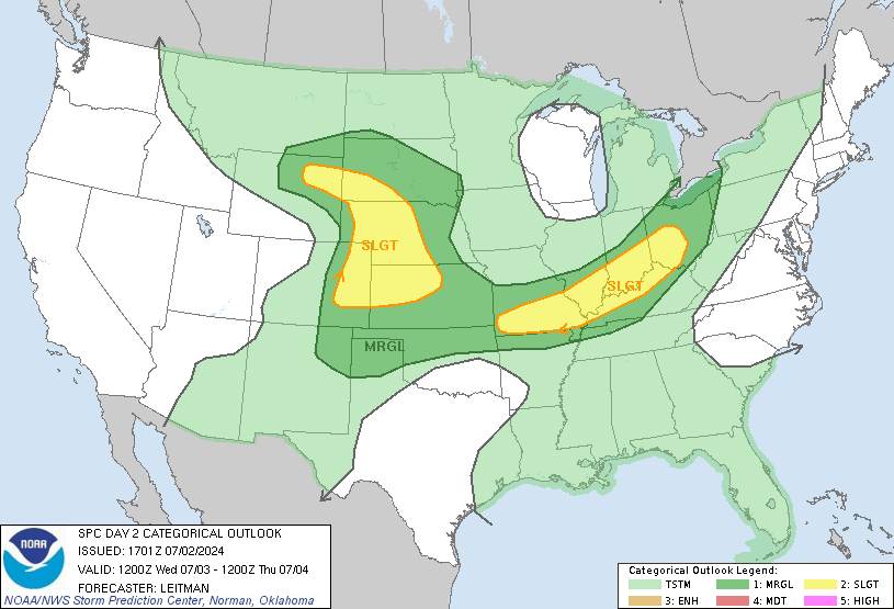
THERE IS A SLGT RISK OF SVR TSTMS ACROSS PARTS OF THE MID MS AND OH VALLEY REGION...
...MID MS/OH VALLEY REGION...
WEAK HEIGHT RISES WILL OVERSPREAD THE MID MS/OH VALLEY REGION WEDNESDAY PRIOR TO SHORT-WAVE TROUGH THAT WILL DIG SEWD INTO THE GREAT LAKES LATE. EARLY IN THE PERIOD LOW LEVEL WARM ADVECTION WILL BE FOCUSED OVER THE UPPER MS VALLEY AHEAD OF SFC LOW OVER SWRN MN AND THIS SHOULD PROVE RESPONSIBLE FOR EARLY MORNING CONVECTION. GIVEN THE PRESENCE OF HEIGHT RISES ACROSS THIS REGION AND THE LIKELIHOOD THAT A STRONG CAP WILL BE PRESENT ACROSS THE MID MS VALLEY...WARM ADVECTION SHOULD PROVE INSTRUMENTAL IN CONVECTIVE DEVELOPMENT THROUGH THE PERIOD. LATEST MODEL GUIDANCE STRONGLY SUPPORTS THE IDEA THAT WARM SECTOR TSTM DEVELOPMENT WILL BE NEGLIGIBLE OR SEVERELY RETARDED DURING THE PERIOD AS WLY FLOW LIMITS DEEPER UPDRAFTS. FOR THIS REASON IT APPEARS ASCENT NORTH-EAST OF RETREATING WARM FRONT WILL DRIVE ELEVATED CONVECTION SEWD ALONG A CORRIDOR FROM SRN WI INTO IL/IND DURING THE DAY. LATEST SHORT RANGE GUIDANCE APPEARS TO BE OVERESTIMATING LOW LEVEL MOISTURE RETURN INTO THIS REGION WITH THE 12Z NAM SUGGESTING MID 60S DEW POINTS WILL RETURN INTO THE WARM FRONTAL ZONE. THIS IS LIKELY TOO HIGH AS TRUE MID 60S DEW POINTS ARE LIMITED TO DEEP SOUTH TX ATTM. EVEN SO...STEEP MID LEVEL LAPSE RATES DO SUGGEST TRANSITORY CLUSTERS OF ELEVATED THUNDERSTORMS COULD PRODUCE HAIL AS THEY SPREAD TOWARD THE OH VALLEY INTO THE EVENING HOURS. IT/S NOT ENTIRELY CLEAR WHETHER BOUNDARY LAYER HEATING WILL BE SUFFICIENT FOR SFC-BASED CONVECTION ACROSS SRN IA/NRN MO AS WEAK CONVERGENCE AND THE AFOREMENTIONED STRONG CAP SHOULD BE NOTED.
SPC has placed much of Indiana, including Central Indiana, under a Slight Risk for Severe Thunderstorms for Tomorrow Evening into Early Thursday Morning
Here we have low threat for tornadoes, a moderate threat for damaging winds and large hail. Our biggest threat will be heavy rainfall. Expecting between 0.5"-0.75" in Central Indiana. Also expect lightning, an attached event for any thunderstorm.
More details on the next rain system in my mid week weather blog tomorrow. We will see more rain chances, and below normal temps over the next 7 days.
Briefly, i'd like to share TWC's hurricane season outlook. Looking to below normal than the past 2 yrs. The more El Nino shapes up the lower the numbers will be this yr in the chart below. For more info on El Nino click HERE. For more info on this hurricane outlook click HERE


No comments:
Post a Comment