May 2012
As the month of May continues, so does the heat. We are averaging a temperature this month of 66°, which is 6° above the normal 60° for the first half of the month. We have recorded 2 days with temps in the 60s, 9 days in the 70s, and 6 days in the 80s. The highest temperature this month, which is also highest of year so far is 85° recorded Thursday, May 3rd. The average high is 77°.
For low temperatures, we've recorded 3 consecutive mornings in the 40s (May 9-11), 9 in the 50s, and 5 in the 60s. Our coolest morning was Thursday, May 10th when the thermometer dropped to 42°. The average low temp this month is 56°.
In terms of precipitation, we are on the low end of the stick. As of May 17, 2012 only 2.10" in the bucket for the month at Indianapolis International Airport. This is just a tad bit below 3" below normal for the month. Looks like we'll finish with below normal precipitation.
It may be warm but nothing abnormal about this month really sticks out. No records set and won't even go as one of the top 10 warmest Mays. We'd need to average a temp of about 70° for May 18-31st. Thats equivalent to an average high of 80° and average low of 60°. This is very unlikely to happen.
Spring 2012
This is the last month of meteorological spring (MAR-APR-MAY). Our average temp this season is 59° with an avg high of 70° and an avg low of 48°. This is good for the warmest Spring on record. We've picked up less than 10" of precip and less than 1" of snow (in March) this spring season. Our last measurable snow fell on Monday, March 5th. Our last Spring Freeze Date was Wednesday, April 11th (29°). Each of the past 9 months have recorded atleast one day with a high temp in the 60s. Pretty Impressive!
This weekend
High pressure will dominate giving us yet another sunny, dry day not only for Fiday but for Saturday and Sunday Afternoon as well. Perfect weather for Pole & Bump Day on the DRY track. We're running out of fingers to count the days since our last raindrop. We'll pass 10 fingers this weekend as our next rain chance will not arrive until Monday.
On average, 16 days out of the month are usually sunny in Indianapolis but we average about 5" of rain which should make May the wettest month of the year. So far we've picked up 2.1", still nearly 3" below normal. Right now, March is our wettest month of 2012 with 4.14", that was 0.58" above normal for that month. Yes, the heat will continue on with high temps expected to remain above 70° for the rest of the month. One problem, the humidity will rise making for an uncomfortable weekend. Also, pollen count levels will be moderately high to high this weekend for Ash, Hickory/Pecan & Mulberry.
Annular Solar Eclipse
An annular solar eclipse will be seen Sunday evening. This is when the moon blocks out most of the sun but leaves a ring of light visible around its circumference. One problem, since the sun will be setting for the East Coast it will not make for the best view for us in Indiana. Visibility will be better for those on the West Coast as they are hours behind us. They'll better see this at 5pm Pacific Time. For us, we can still take a glance around 8pm Eastern Time. Keep in mind using a magnifying glass and the sun creates a burn (or fire), this is no different from looking through binocolurs or telescopes which could potentially damage your eyes. You can use a solar safe telescope with the appropriate filters or you'll need to make a Pinhole Projection to safely view the Eclipse. Click HERE for more instructions.
 |
 |
Next Week
A cold front will approach late Sunday or early Monday along with it our air will become unstable. This could result in shower activity for the start of the work week. Not looking at much rainfall at all though but we can take whatever we can get. Monday looks to be our best chance with a slight chance for Tuesday and completely end up rain free on Wednesday but I still threw in a small chance for Wednesday.
 |
 |
 |
 |
Temps pull back to 70s to start the work week but another of surge of heat will arrive next Thursday to linger into the Race Day weekend with temps in the mid to upper 80s, with some places in the state possibly reaching 90s. This could potentially be the warmest, most humid air of the year so far for 2012.
What's Ahead
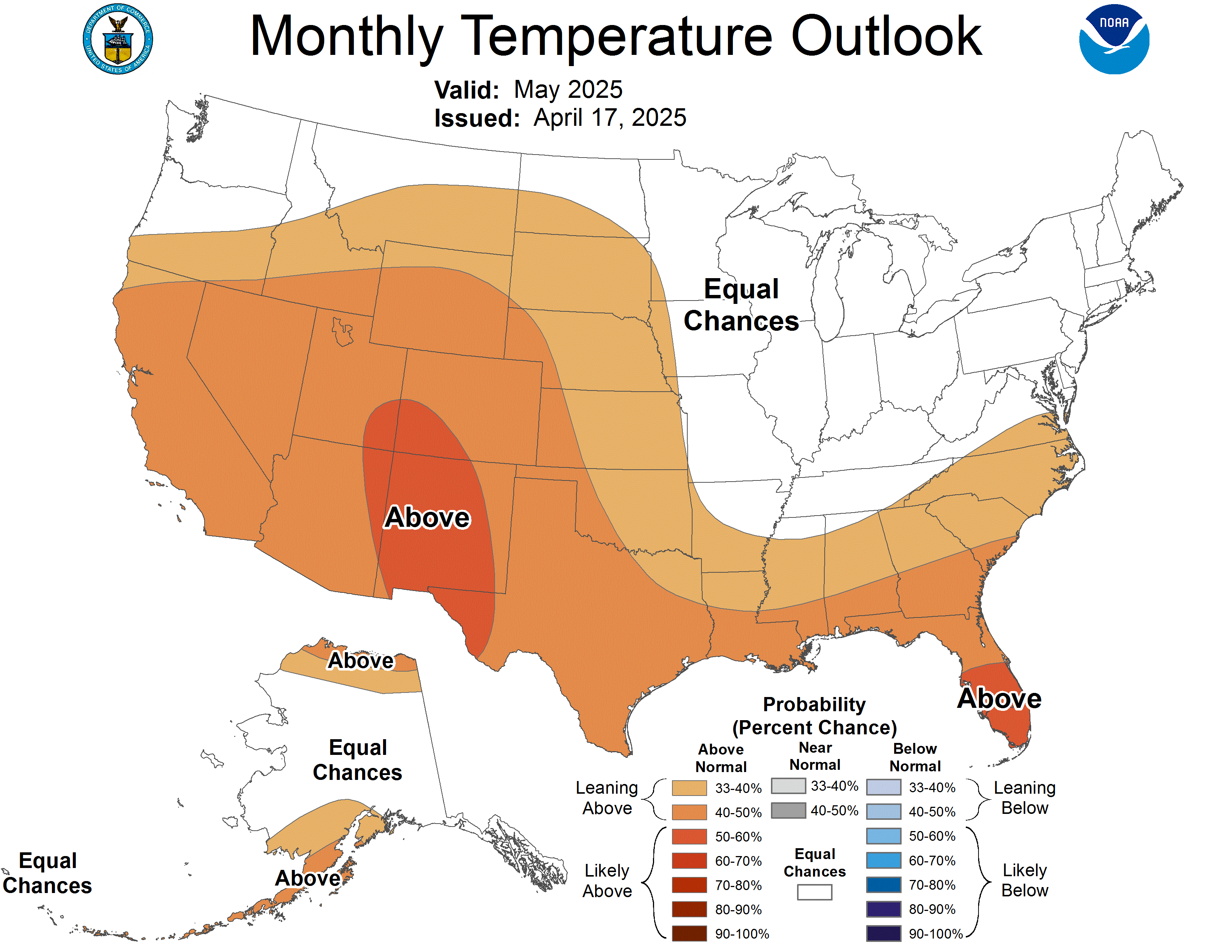
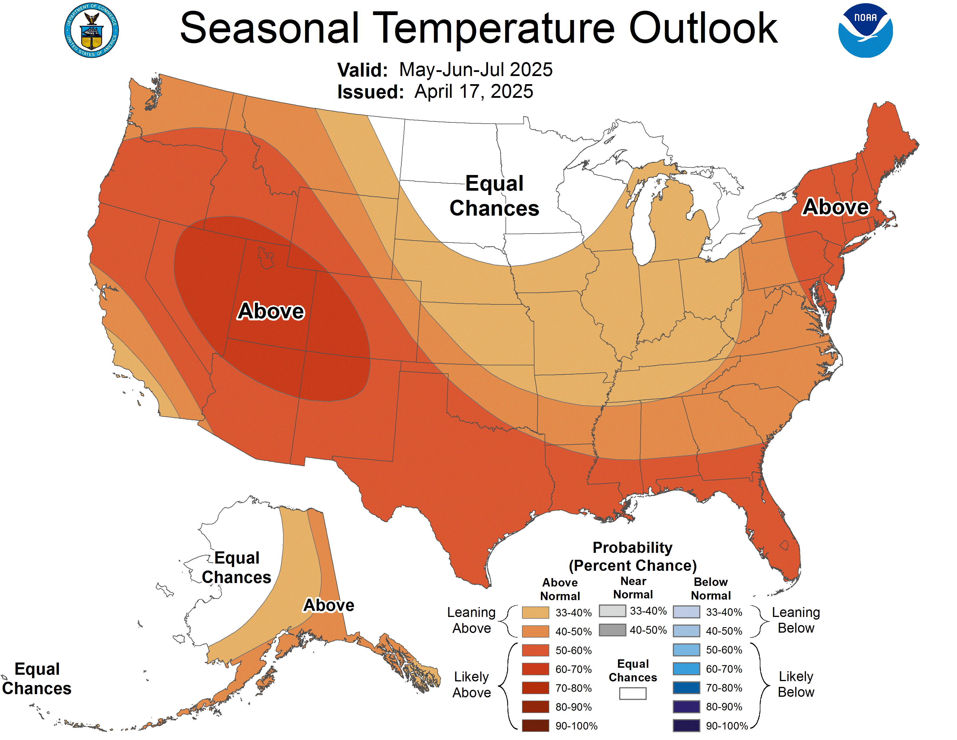
Summer Outlooks are out and it appears there has been some changes from the past few months. It was looking like temperatures would be at normal values but now as we get closer, we could be looking at a hot summer with above average temps. I still don't believe we'll be scorching hot as last summer though. From May-September 2011, we recorded 61 days with high temps in the 80s, 40 days in 90s, and 2 days topping 100°. Another quick recap of last summers heat to come in a future blog.
 |
 |
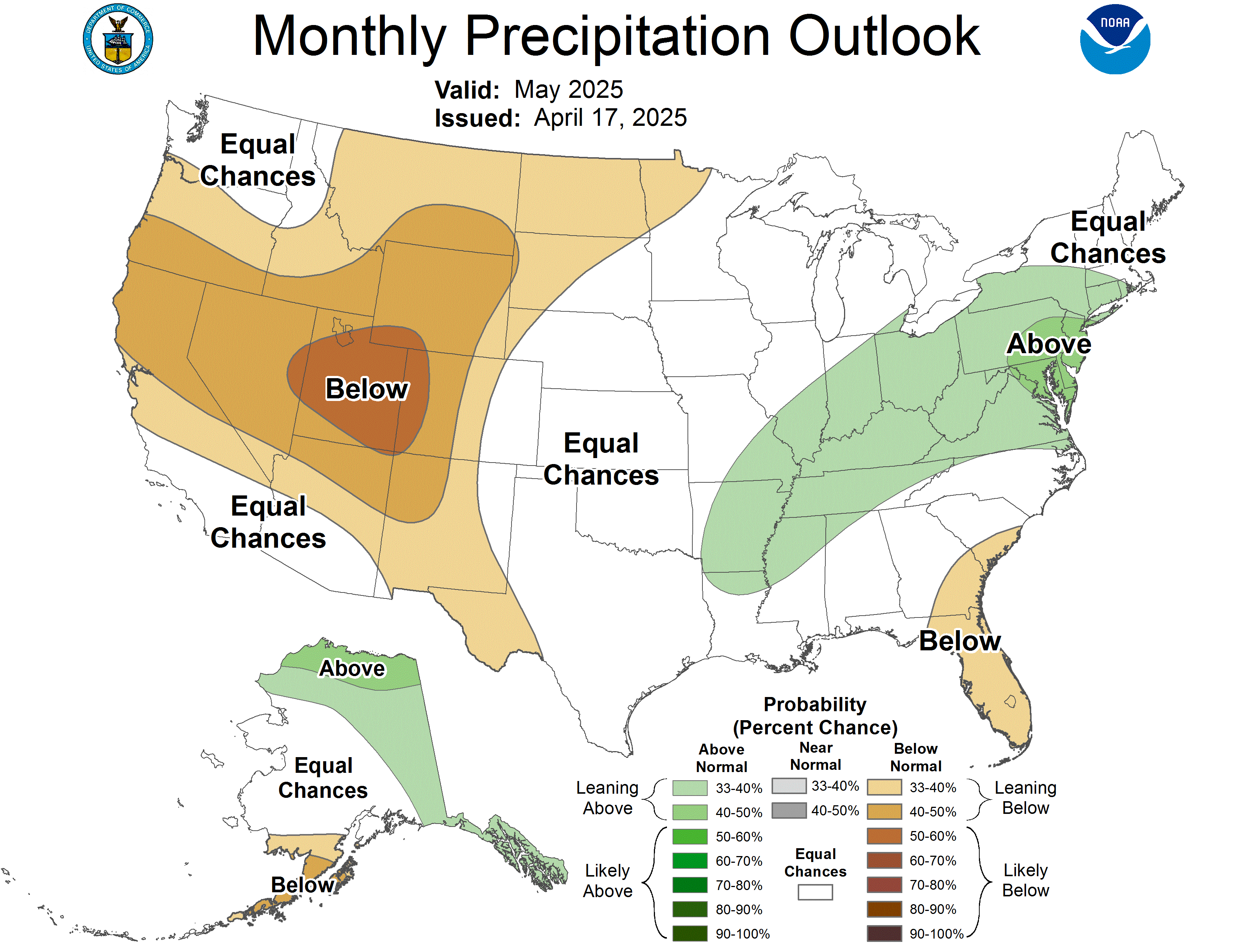
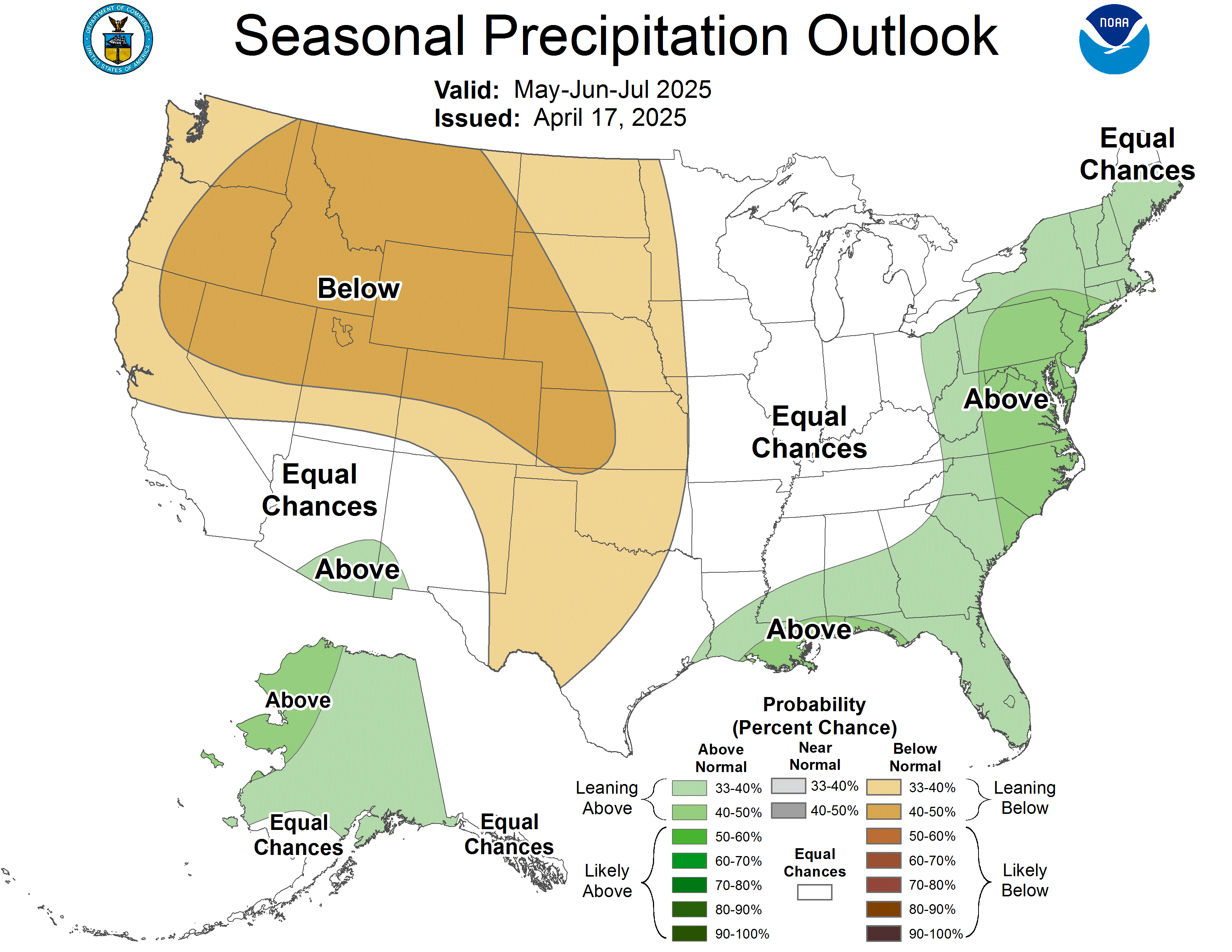
At the moment, precipitation is questionable. We have an equal chance of below, near, or above normal precipitation. For JUN-JUL-AUG last year we picked up less than 7.5" of rainfall, over 4.5" below normal for the entire summer season. The avg summer season precipitation is about 12". Last July, we picked up the lowest amount for the year with only 0.47" for the month.
 |
 |
Special Notes/Tips
As we approach warmer temperatures and higher humidity this adds to the dangers for hazardous health conditions that can damage your body or lead to fatalities without taking extra precautions of safe, proper care/treatments. Make sure you are hydrating by drinking plenty of water or some sport drinks. Avoid drinking carbonated beverages that could lead to heat cramps. As sun does contain some Vitamin D for your for body, avoid prolonged exposure as this could damage your skin. If engaged in outdoor activities leaving you with prolonged exposure to the sun, wear sunglasses and suncreen.
Vitamin D maintains normal blood levels of calcium and phosphorus in the human body and can possibly help prevent osteoporosis, high blood pressure, and even depression. The recommended exposure time to sunlight without sunscreen is only 10-15 mins per day, 2-3 times per week between 8AM-4PM. Longer unprotected exposure can lead to skin cancer. Currently, FDA has mandated new labels for sunscreen and manufacturers have until early fall to comply with the new label requirements. The main thing you need to know is Sunscreen is good for atleast 2 hrs and then you must reapply. If your in and out of water it may be good for 40-80 mins. SPF 30 is recommended but 45 is highly recommended especially if your outside for a longer period of time.
Also, keep in mind, childrens and pets should not be left in the vehicle in the heat. This is dangerous and could lead to death as well especially during long periods of time and inadequate cool ventillation. About 400 people are killed and 6200 people hospitalized every year in the U.S. due to excessive heat. Please follow safe precautions this summer. Don't become a part of this statistic. For more information on Heat Safety click HERE.
10 Day Detailed Forecast
Friday-Sunny. High 83.
Friday PM-Clear Skies. Low 60.
Saturday-Sunny. Warmer. High 85.
Saturday PM-Clear. Low 62.
Sunday-Sunny. High 87.
Sunday PM-Parttly Cloudy. Chance of Rain/T'Storms. Low 64
Monday-Partly Cloudy. Showers/T'Storms. High 79.
Monday PM-Partly Cloudy. Chance of Showers/T'storms. Low 59.
Tuesday-Partly Cloudy. Chance of Showers/T'Storms. High 74.
Tuesday PM-Partly Cloudy. Chance of Rain. Low 60.
Wednesday-Mixed Sun & Clouds. Chance of Showers/Storms. High 78.
Wednesday PM-Clear. Low 62.
Thursday-Sunny & Warmer. High 84.
Thursday PM-Clear. Low 63.
Friday-Sunny. Humid. High 87.
Friday PM-Clear. Low 69.
Saturday-Mixed Sun and Clouds. Humid. High 88.
Saturday PM-Partly to Mostly Clear. Low 68.
Sunday-Sunny. Humid. High 84.
Sunday PM-Clear. Slightly Cooler. Low 64.
Temperature Data for May 1st-18th
MAY 2012 AVG HIGH---76.9°. This temperature is 4° above the normal avg high of 73° for May.
MAY 2012 AVG LOW----55.5°. This temperature is 2° above the normal avg low of 53° for May.
MAY 2012 AVG TEMP--66.2°. This temperature is is 3° above the normal avg temp of 63° fforr May/
Precipitation Data
Precip since MAY 1----2.10". This is 2.95" below normal for month.
Precip since MAR 1----9.60". This is 2.82" below normal for season.
Precip since JAN 1-----14.46". This is 3.03" below normal for year.
Snowfall Data
Snowfall Since MAY 1----NONE
Snowfall Since MAR 1----0.70"
Snowfall Since JAN 1-----7.50"
Snowfall Since NOV 1----9.8"
No comments:
Post a Comment