SO,WHAT WOULD YOU HAVE DONE IF THE SIRENS YOU HEARD WAS NOT A DRILL AND A REAL TORNADO WAS OCCURRING?

What is the difference between a watch and a warning?
According to NOAA guidelines, a severe thunderstorm watch means that the potential exists for the development of thunderstorms which may produce large hail (of 0.75" or greater diameter) and/or damaging winds (with gusts 58 mph or greater). As with any storm (weak, strong, or severe) there is atleast a 1% chance for the formation of tornadoes. When a watch is issued, it is permissible that you go about your normal activities, BUT strongly advised you keep an eye to the sky and an ear to the National Weather Service's weather radio, local radio, and/or television stations for further updates and possible warnings.
A severe thunderstorm watch is likely to be issued a few hours in advance. It doesn't necessarily means severe weather is occurring in the area but rather severe weather should be expected to reach our area shortly. When we see severe weather, that warning will be upgraded to a severe thunderstorm warning.
When you see a tornado watch this means conditions are favorable for tornadoes to develop. When there are actually tornadoes forming and reaching the gound, the watch is then upgraded to a tornado warning.
.jpg) |
You may see a PDS WATCH! "THIS IS A PARTICULARLY DANGEROUS SITUTATION". This is when long lived, violent tornadoes are possible. You are likely to see these PDS watches issued with a high risk severe weather outlook.

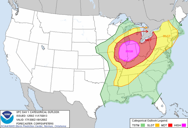
National Oceanic Atmospheric Administration (NOAA) Storm Prediction Center (SPC) monitors the weather pattern and if convective potential exists, they will highlight an area certain colors in their convective outlook maps. These colors mean various things which can be broken down into several levels of risk categories (shared below). These convective outlooks are used as a guidance for NWS local offices. They are most frequently used by emergency managers, private sector meteorologists, media, and other weather customers concerned with public safety. The convective outlooks go out a few days in advanced and are constantly updated a few times a day everyday. You'll see these outlooks titled Day 1, Day 2, Day 3, and Day 4-8 convective, categorical, or Severe Thunderstorm outlook.
- RISK CATEGORY 1 (GREEN): When you see this shaded on the map (see example below), this means non severe thunderstorms are possible.
NOTE: Not all thunderstorms are strong or severe. - RISK CATEGORY 2 (SEE TEXT): You may or may not see an area shaded, but rather see the words, "SEE TEXT". This is when severe weather is possible but uncertain as to whether the potential really exists. Its likely to serve as a general notice that thunderstorms are possible, severe or non-severe.
- RISK CATEGORY 3 (YELLOW): When you see an area shaded yellow on the map (see example below), this means there is a SLIGHT risk for severe thunderstorms. You'll see the text abbreviation SLGT on the map.
- RISK CATEGORY 4 (RED): When you see an area shaded red on the map (see example below), this means there is a MODERATE risk for severe thunderstorms. The area shaded implies a greater concentration of severe thunderstorms, and in most situations, greater magnitude of severe weather and greater forecaster confidence compared to a SLIGHT risk. In other words, those in "red" are more likely to see severe thunderstorms than those in "yellow" and/or likely to see storms stronger. Those under a MODERATE risk are likely to see multiple tornadic supercells with very large hail, or intense squall lines with widespread damaging winds. You'll see the text abbreviation MDT on the map.
- RISK CATEGORY 5 (PINK): When you see an area shaded pink on the map (see example below), this means there is a HIGH risk for severe thunderstorms. The issuance of a high risk is rare and is reserved for the most extreme situations. The area shaded implies a major severe weather outbreak is expected, with large coverage of severe weather and the likelihood of extreme severe, violent tornadoes and/or very damaging convective wind events. You'll see the text HIGH on the map.
So now you know the various weather outlooks and watches/warnings. The question now turns to;
WHAT SHOULD I DO WHEN SEVERE WEATHER IS EXPECTED TO STRIKE OR IS HAPPENING NOW?
- IMPLEMENT YOUR EMERGENCY PLAN: Before the storm even hits, you should have already came up with a plan. If not, you need to get with all the members of your household and come up with plan as to where everyone will go when either a Severe T'Storm or Tornado Watches or Warnings are issued. This could also mean evacuation. It could be possible that your living conditions may not make suitable for a safe location. Travel on the roads is highly discouraged. If you have a relative with lets say a basement this could make for better conditions to keep your family safe. Gather up over there, and make sure everyone is accounted for. This is one way that will help save you and/or your family's life. If this is not possible, go to the lowest level of your home and get into the closet or bathroom where there are no windows.
- HAVE A NOAA WEATHER RADIO: It is recommended that you get a radio that will sound off an alarm when severe weather is in the area. You will be able to take heed of watches and warnings and quickly respond by initiating your Emergency Plan you and your family have in place. You can buy these from stores, online, or even download apps on iPhone from iTunes or on your Android smartphone devices via the Android Market. (Click Link That Applies to you).
NOTE: If you lose cell phone coverage, these weather apps will NOT work. It is highly recommended you rely on a weather radio and not your phone. - TAKE ACTION ON THE ROADS: If you are on the road driving, it is a MUST, THAT YOU NEVER PARK UNDER A OVERPASS OR BRIDGE! If a Tornado is present DO NOT TRY TO OUTDRIVE IT! The best you can do is pull over and take shelter in a nearby building or lie down in ditch, or a low lying area. Parking under the overpass blocks emergency vehicles from getting by, thus, preventing them from doing their jobs, responding to those in need of help. Parking underneath is also dangerous, have you heard of the wind tunnel effect? When wind is channeled through a narrow space such as underneath a overpass or bridge, wind speed is increased which is more dangerous than if you weren't parked underneath. SO DON'T DO IT!
- PREPARE A SAFETY KIT: Gather up a Severe Weather Emergency Kit. You can use this in case of a power outage. Batteries, Flashlights, Clean Clothes, Blankets, Dry Food & Water for atleast 3 days are a few things you can put in there. If you do not have a car charger, GET ONE! You can use your car's cigarette lighter to recharge your phone's battery. Some cases could leave your homes power out for days or weeks. Make sure you have what you need to get you through this time.

.jpg)
Follow NWS Indianapolis, Indiana on twitter @NWSIndianapolis and like them on Facebook. Follow NWS Northern Indiana on twitter @NWSIWX and like them on Facebook. These sources issues weather and flood warnings and daily public forecasts to meet their mission of protecting life and property in all counties in Indiana.
This is an example of the map you will see on the homepage outlining all watches and warnings. You may click these watches and warnings when they are in effect to get more information. Information you will see is an outline of the reason behind the watch or warning issued such as the weather we are expected to see and a timeline of the watch/warning (when does it expire?). Something to note, watches can cover a larger amount of time while warnings are meant to cover a shorter length of time. A warning can be extended, if necessary.

From the homepage, you can click on your county to get a forecast for the next week. Once you click on your county, you'll be taken to a webpage similar to the one below. Notice the red box? This is where weather statement and watches and warning effective will be positioned. You can click the link or links to view more information. Same information I just talked about a few seconds ago. I hope this information helps. In addition to that, you'll find all various weather sources providing you with the same information as well as local television stations around the state.

You can also follow the Indiana Department of Public Safety & Indiana Department of Homeland Security. Here is their mission statement:
Prepare for, respond to, mitigate and coordinate recovery from catastrophic events, through plans, policies, and procedures to minimize the impact of those events upon the citizens of Indianapolis and Marion County to ensure the timely restoration of services and a return to normalcy.Follow DHS on twitter @IDHS and on Facebook. Follow Indianapolis Division of Homeland Security on twitter @DHSIndianapolis and like them on Facebook. Follow DPS on twitter @Indy_DPS and like them on Facebook.
NOTE: I provided these social media links for reference only for direct information related to the weather and disaster relief. I do not work for NWS, DHS and DPS and they do not endorse any non-government websites, companies or applications. The information gathered in this blog is for safety awareness and was provided courtesy of information gathered from the NWS and Ready.gov.
No comments:
Post a Comment