We just wrapped up our 5th warmest December on record with an average temperature of 42.1° which was nearly 9° above normal. The month also produced a record 11 days with high temperatures of 60+ besting the previous record of 10 days set 133 years ago in 1889. The incredible warmth left no room for any snow to fall and with only trace amounts it ties as the 2nd least snowiest December on record. Only 3 out of the 31 days were below normal, with only one of those days being the only day to dropped below 20°. An occurence that hasn't happened for six years and marks only the 13th time for this occurence to happen over the past 150 years. (NOTE: Of those 13 years, there were five years where all 31 days of December remained 20+ degrees).
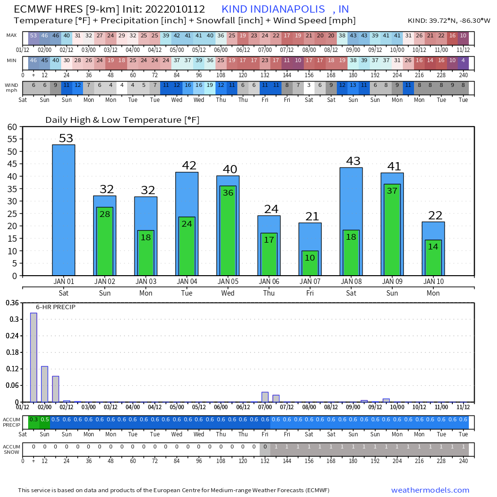
As I previously mentioned in my last blog, the high temperature of 61° for today (January 1, 2022), which was reached early during the midnight hours, is good for the 5th warmest New Year's Day and warmest in 37 years (62° in 1985). Temps thus far, have dropped into the lower 40s and with only a few hours left of the day, it's likely we will record our day's minimum temperature in the final minutes. On average, temperatures today have ran 30° above normal.
Rain showers have been light today but with 0.41" total in the bucket through 10:00 PM, this marks for atleast the 14th wettest New Year's Day on record. Again, if you can remember last year's 0.77" was the 6th wettest for the date. we will keep the chance for a few more showers for a few more hours but as colder air continues to advance towards the city, some mixing of snow will begin to occur. Temperatures will quickly drop from 41° at 10:00 PM this evening to 27&176; by sunrise tomorrow (which occurs at 8:06 AM). Even though some mixing will occur with the drop in temperatures, there shouldn't be any major concerns for freezing rain. Though you may want to be careful as the wet pavement could turns icy in spots. The atmosphere will continue to become moisture deprived on Sunday but with a lingering cloud deck through the morning and afternoon hours there could likely still be just enough to generature a few snow showers/flurries on Sunday. Any sunshine that manages to break through in the afternoon may be very limited. Under these conditions in combination with cold air advection, signifcant warming just isn't feasible on Sunday and temperatures will remain below the freeze point threshold through atleast either Monday or Tuesday afternoon. Sunday will also be a bit breezy with gusts at 25 mph at times.
Looking ahead, clouds will finally begin to clear out heading into Monday allowing the return of some sunshine that will persist into Tuesday. We will still be under the influence of Canadian high pressure so temperatures will be a tad bit frigid in the teens with wind chills in the single digits on Monday. Don't worry, the pullback in temperatures will be brief as winds looks to shift back to the South allowing afternoon highs to climb back above normal for Tuesday and Wednesday but not to the same magnitude we have seen in recent weeks. Clouds will return for Wednesday with the arrival of our next frontal passage and a passing disturbance to the North.
As we get into the heart of winter, colder and snowier days will become more frequent in the days and weeks ahead. A polar air mass is expected to invade at the end of the week. Will monitor as there is low confidence in the specifics of this evolving pattern but the idea is for some spots to drop into the single digits. The arrival may bring a few snow showers with it on Thursday and early Friday across the Great Lakes and Ohio Valley region.
No comments:
Post a Comment