Another warm jab is a welcomed sight as many areas in Central Indiana saw 40s for both Tuesday afternoon and Wednesday morning. Unfortunately jabs are quick and arctic intrusions look plentiful as we get deep into the back half of the month. January is statistically our coldest and most snowiest month of the year but this season has been a strange one. Typically snow and cold go hand in hand during the winter but only 0.8" has been measured on the sticks in total so far this season. The snowfall deficit continues to grow to around a foot below normal making for the least snowiest winter to date. We've seen some pretty vicious snow storms before in February and March so there is still time left to make up the loss. We saw a double hitter in February 2014 10 days apart with nearly 7" recorded on the 4th and later nearly 6" on Valentine's Day. The most snowiest day in February was 10" on the 16th in 1910. The month of March takes it a step further with 12.1" in the books on the 19th in 1906. Just recently, in 2018, we received 10.2" in a single calendar day on March 24. Snow or no snow, winter continues to roll on and Spring's arrival is fastly approaching, officially in less than 60 days.
REST OF THE WEEK AND WEEKEND
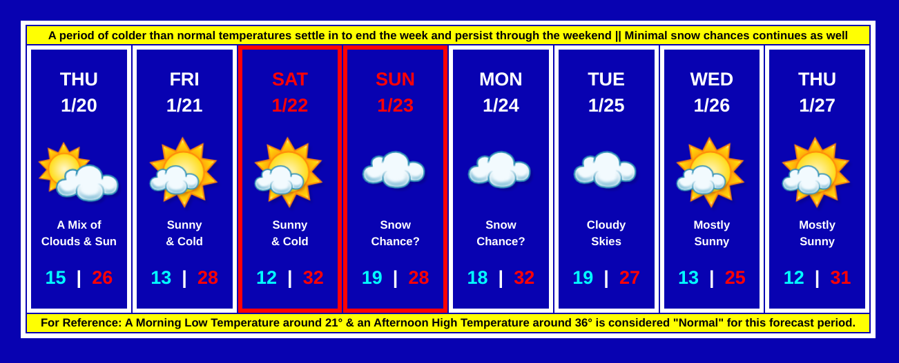
Time is beginning to expire on this push of unseasonable warm air. A cold front sweeping past the state from NW to SE will drastically drop temperatures below freezing before or around sunset this evening. This arctic airmass sliding in will continue to deepen in the midnight hours. In combination with winds 10-15 mph, this will allowing wind chills to fall near or below zero tomorrow morning. Clouds will likely remain in place throughout the afternoon and evening hours but may begin to show some breakage in the overnight hours with sunshine peaking through at times during the daytime hours on Thursday. Though there may be a few lake enhanced clouds Thursday afternoon, dry, quiet weather is expected to bookend the week. Sunshine is likely for both Friday and Saturday but clouds will increase on Saturday ahead of a disturbance passing through on Sunday that may bring a chance for a few light snow showers. Confidence is not the greatest given the track record for the season but will continue to monitor the trends and update the forecast accordingly. For now, expect minimal impacts from the clippers on Sunday and possiby Monday too. Morning lows will likely range from the lower to upper teens and afternoon highs will range from the middle 20s to the lower 30s. Much of the next 2 weeks is expected to be below normal in both temperatures and snowfall.
No comments:
Post a Comment