SEPTEMBER 2013 INDIANAPOLIS CLIMATE SUMMARY
We did open the month warm. We were caught up in the passage of 2 frontal systems. The high temp of 85 on the 1st was knocked back to 76 on the 3rd. Though we only recorded a trace of precipitation, the cool down was very brief and warmer temperatures quickly returned. Its interesting to note that the 1st 11 days (execpt September 3rd) saw a high 84+. This was actually nearly a continuous streak that started back on August 19th (23 of 24 days). We reached the 90s from September 9th-11th. On September 10th we reached a record 96° & tied the warmest low temp of 74. This was the hottest day since August 8, 2012. Then On September 11th, we tied the record high of 95 and tied the warmest low of 72. The daily average temp during the period of Sept 9th-11th was 80+, the last time this occurred so late in the year was 74 years ago in 1939.
| DAY OF THE WEEK |
RECORD HIGH TEMP |
PREVIOUS RECORD TEMP |
HIGHEST MINIMUM TEMP |
PREVIOUS RECORD TEMP |
| TUES SEPT. 10th |
96° (NEW RECORD) |
95° (1964/1983) |
74° (TIED) |
74° (1919) |
| WEDS SEPT. 11th |
95° (TIED) |
95° (1897) |
72° (TIED) |
72° (1900/1931) |
.png)
Since the average temperature was decreasing during the month, we were able to finish the month warm enough to be 1-7ˌ above normal from the 24th-30th. This put the months average temperature at 69.5° which was 2.6° above normal (66.9°)
On the 29th, another cold front moved through that also generated a half inch of precipitation. This brought's the months final rainfall tally to 2.86". The month finished 0.26" below normal (3.12").
Overall, September 2013 finished as the 36th warmest and 69th wettest on record.

Here's a look back at this year's temp and precip rankings.
| MONTH | AVG TEMP |
TEMP DEPARTURE FROM NORMAL |
TEMP RANKING |
TOTAL PRECIP |
PRECIP DEPARTURE FROM NORMAL |
PRECIP RANKING |
TOTAL SNOWFALL |
SNOWFALL DEPARTURE FROM NORMAL |
SNOWFALL RANKING |
| JANUARY | 29.9° | +1.8° | 58th Warmest | 5.51" | +2.85" | 16th Wettest | 2.4" | -6.2" | 35th least snowiest |
| FEBRUARY | 30.9° | -1.2° | 66th Coolest | 2.27" | -0.05" | 71st Driest | 2.6" | -3.9" | 46th least snowiest |
| MARCH | 35.5° | -6.7° | 14th Coolest | 1.96" | -1.60" | 30th Driest | 14.5" | +11.9" | 4th Snowiest |
| APRIL | 52.5° | -0.5° | 74th Coolest | 8.59" | +4.78" | 2nd Wettest | TRACE | -0.2" | N/A |
| MAY | 65.4° | +2.7° | 34th Warmest | 3.50" | -1.55" | 60th Driest | NONE | 0.00" | N/A |
| JUNE | 72° | 0.0° | 71st Warmest | 3.66" | -0.59" | 69th Driest | NONE | 0.00" | N/A |
| JULY | 73.9° | -1.5° | 30th Coolest | 3.29" | -1.26" | 71st Driest | NONE | 0.00" | N/A |
| AUGUST | 74.9° | +0.7° | 43rd Warmest | 1.15" | -1.98" | 12th Driest | NONE | 0.00" | N/A |
| SEPTEMBER | 69.5° | +2.6° | 36th Warmest | 2.86" | -0.26" | 69th Wettest | NONE | 0.00" | N/A |
| JAN-SEPT | 56° | -0.2° | N/A | 32.79 | +0.34" | N/A | 19.5" | +1.6" | N/A |
SKYWATCH
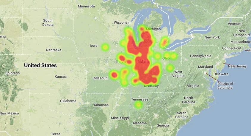
There was sightings of fireballs late September. The AMS received nearly 700 reports of a large fireball the morning of September 26th around 7:05 am local time. Witnesses from Ohio, Illinois, Indiana, Kentucky, Missouri and Wisconsin reported a bright light moving across the morning sky. Check out this heat map.
The AMS is always receiving reports of fireballs, some of which have yet to be reviewed or confirmed. You can check the reports at the following url address:
http://www.amsmeteors.org/fireballs/fireball-report/
Some areas got a glimpse of the Northern Lights and Draconid meteor showers over the past week. Next up..the Orionid meteor shows. This becomes visible October 20-21st. They'll be coming in at 10-20 meteors per hour. Meteors are best viewable away from city lights and before dawn. You may see some early AM on October 20th, 21st, & 22nd. I will note though, they'll be a little harder to see as the moon will be about 95% visible. The full (hunter's) moon comes right before it on October 18th. The next meteor shower event is the South Taurids on November 4-5.
The moon is 100% full on October 18th (7:38pm). This month's moon is called Hunter's Moon as it is the time to hunt in preparation for winter. Other names is Harvest Moon, Travel Moon, Dying Grass Moon, and Blood Moon.
METEOROLOGICAL FALL & OCTOBER 2013

DROUGHT ANALYSIS
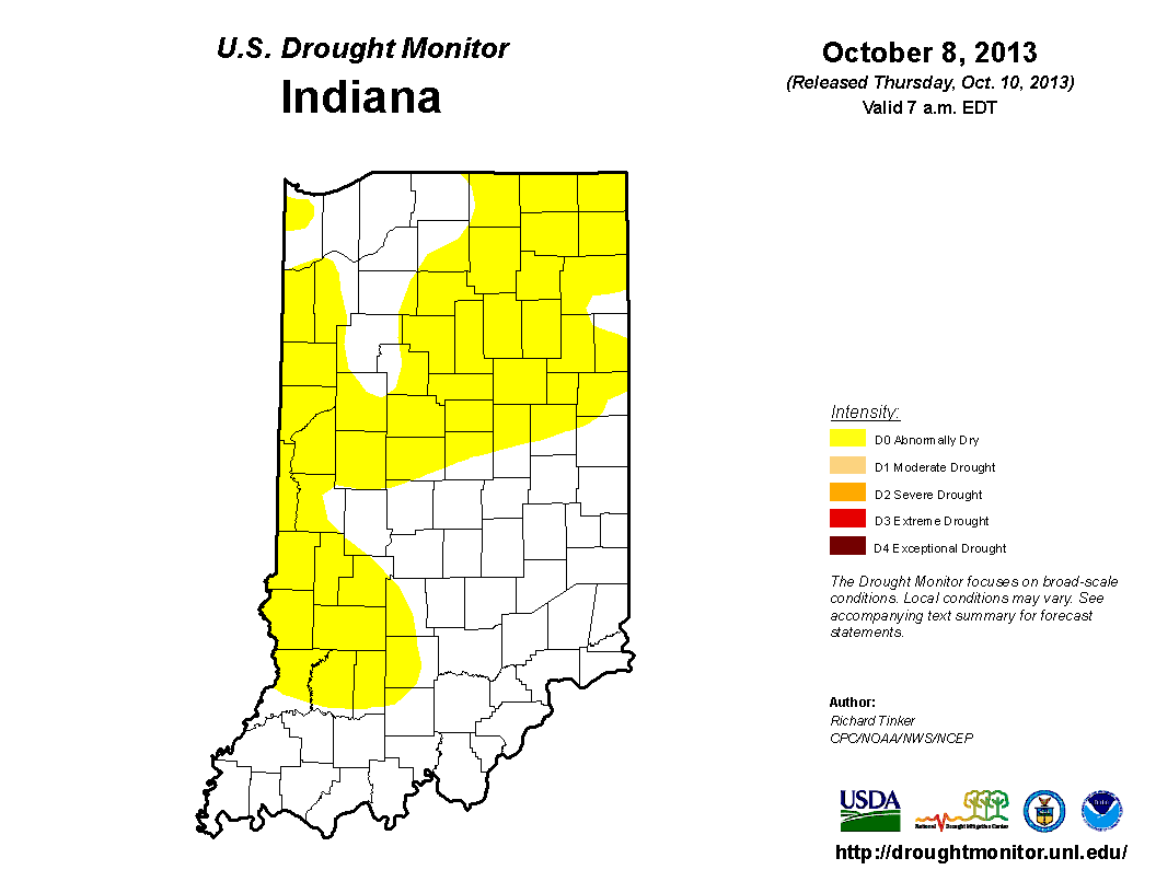
Latest drought map was released this morning. Most areas around the state received some beneficial rain over the past week, therefore, the 3% of the state that was in a moderate drought has been downgraded. 53% of the state that was abnormally dry has been cut back to 46%. Here's a look at the precipitation maps for October 4th, 5th, & 6th when over 2" fell here in Indianapolis. Even higher totals to the South. Bloomington received over 4". Central parts of the state are now no longer abnormally dry.
 |
 |
 |
Here's a look at the latest drought map.
Here's a look at the updated Indiana rainfall deficit table (valid thru October 9). Lots of areas are above normal in precipitation not only for this month but for the fall season so far.
| LOCATION | YEAR TO DATE PRECIP (thru Oct. 9) |
DEPARTURE FROM NORMAL |
PRECIP SINCE SEPT. 1st |
DEPARTURE FROM NORMAL |
MONTH TO DATE PRECIP |
DEPARTURE FROM NORMAL |
| BLOOMINGTON | 36.45 | -1.11 | 6.13 | +1.76 | 4.27 | +3.25 |
| EVANSVILLE | 42.41 | +7.51 | 7.08 | +3.10 | 4.27 | +3.34 |
| FT. WAYNE | 35.49 | +4.99 | 3.15 | -0.51 | 1.26 | +0.40 |
| INDIANAPOLIS | 35.36 | +1.96 | 5.43 | +1.36 | 2.57 | +1.62 |
| INDIANAPOLIS EAGLE CREEK |
32.84 | +1.00 | 5.35 | +2.16 | 3.04 | +2.10 |
| LAFAYETTE | 33.38 | +4.27 | 5.75 | +2.19 | 1.82 | +0.92 |
| MUNCIE | 30.45 | -1.33 | 5.57 | +1.70 | 1.78 | +0.87 |
| SHELBYVILLE | 25.65 | -8.77 | 4.24 | +0.10 | 2.21 | +1.24 |
| SOUTH BEND | 32.19 | +2.39 | 5.27 | +0.74 | 1.15 | +0.15 |
| TERRE HAUTE | 35.42 | -0.28 | 2.39 | -2.03 | 1.19 | +0.19 |
THIS WEEK
October is generally ranked as the 4th most sunniest month of the year and indeed there was more sunshine on tap for us today. There was a few clouds so it broke our 2 day streak we had going. October 8th & 9th saw 100% of its possible sun with NOT A SINGLE CLOUD IN THE SKY. This was the most sunniest back to back days since December 10 & 11th of 2011.
Each of the days this weeks has been warmer than the previous after the storm system passed last weekend. Monday's high of 62 jumped to 70 for Tuesday then 72 yesterday. Today, we started with a low temperature of 50 but warmed up to a high of 74. Today did finish above normal. 7 out of 10 days so far this month have been above normal. The normal high for today is 67° and the normal low is 46. No precipitation was recorded.
TONIGHT
Skies will continue to be clear and temperatures will drop to a low in the mid to low 50s. The targeted (forecast) low is 52.
FRIDAY
Sunny, pleasant, mild, & warmer. High 75.
UPCOMING...
There are indications that we have some even chillier air than Monday's high of 62 coming our way. Temps look to drop back into the 50s and before months end, we may see our 1st freeze which could came at the earliest on October 21st or 22nd. You can see the cool down that headed our way at the latter part of my 10 day forecast at the end of the blog. Before I get to that, I want to share with you 1st freeze dates over the past 10 years and other "chilling" stats.
- Last day w/ a high temp in the 50s: May 12, 2013 (57°)
- Last day w/ a high temp in the 40s: April 20, 2013 (48°)
- Last day w/ a high temp in the 30s: March 26, 2013 (39°)
- Last day w/ a high temp in the 20s: February 10, 2013 (17°)
- Last day w/ a high temp in the teens: February 1st, 2013 (16°)
- Last day w/ a high temp in the single digits: February 15, 2009 (7°)
- Last subzero high: January 18, 1994 (-4°)
- Last low temp in the 30s: May 13, 2013 (37°)
- Last low temp in the 20s: April 3, 2013 (25°)
- Last low temp in the teens: March 21, 2013 (16°)
- Last low temp in the single digits : February 1, 2013 (5°)
- Last subzero low February 10, 2011 (-1°)
- Last Freeze Date: April 20, 2013 (30°)
- Last Hard Freeze: April 3, 2013 (25°)
- Last day w/ measurable snow: March 26, 2013 (0.1”)
- Last day w/ a trace of snow: April 19th
- Last years 1st Freeze: October 8, 2012 (31°)
- Last years 1st Hard Freeze: November 6, 2012 (28°)
- Last years 1st trace of snow: October 30, 2012
- Last years 1st measurable snow: November 12, 2012 (0.2")

Check out the 500mb Height, Temperature, & Wind map from this mornings ECMWF (European) 12z run. Note the chilly air diving into the (upper) midwest region. This is a look at Sunday, October 20th at 8AM. If you look at the lines you also see the 540 line up in Michigan. Good indication that temps may be at or near the freeze point. Again, there's a possibility sometime between October 20th-26th we will see our 1st freeze of the season. This will be something to watch. I will monitor and update in the coming days. My 10 day weather outlook is posted afterwards.


No comments:
Post a Comment