Today we have some showers to contend with. Modeling date doesn't suggest that we will be dealing with heavy rain totals. We are only expecting totals at around a quarter of an inch. Its possible some location may reach a half inch. Here's a look at the latest radar animation. This is may be different than what you are reading. The information in this section is valid at 11am. You can see a line of showers crossing from Illinois into Indiana. Some spotty showers could be possible ahead of the line. This line of showers is also associated with a cold front that will usher in cooler temperatures for tomorrow, or rather the remainder of the week I should say. Temperatures today is a little tricky, some models hint at 70s but I honestly don't think we'll get that high with overcast skies & rain chances going up. I'm leaning more towards the mid 60s. The 11AM temp is at 59°.
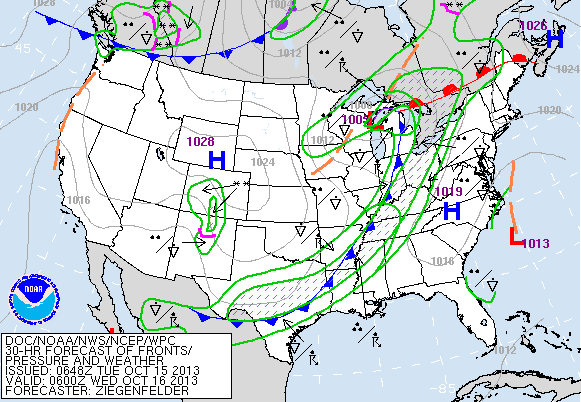
The blue line crossing through Indiana in the image below is the cold front that is expected to pass through overnight. Temperatures on Wednesday will barely make it out of the 50s. Some locations especially North, may fail to do so.

Note the cooler temperature gradient for tomorrow.

Winds will be streaming in from the west-northwest on Wednesday at 5-15mph, w/ gusts 15-20mph.

I'm not going to go into much details today but there are indications that we may see our 1st frost/freeze and possibly some snow showers before month's end. Temperatures to end October will be cold and for the Halloween Trick or Treaters, temps will be below normal. Last year, the high on Halloween was only 45 and the day before we recorded trace amounts of wintry precipitation. Could we be headed back into that direction? Its not set in stone & I will continue to monitor the upcoming pattern. I can say that the 2nd half of October will be much cooler than the 1st half. The average high on October 31st (Halloween) is 60 and the average low is 41.


No comments:
Post a Comment